 Catalogue PIGMA
/Physical Oceanography/Currents
Type of resources
Available actions
Topics
Keywords
Contact for the resource
Provided by
Years
Formats
Representation types
status
Resolution
-
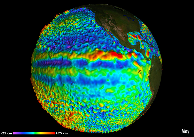
For the Global Ocean - Multimission altimeter satellite gridded sea surface heights and derived variables computed with respect to a twenty-year mean. Previously distributed by Aviso+, no change in the scientific content. All the missions are homogenized with respect to a reference mission which is currently Jason-3. The acquisition of various altimeter data is a few days at most. The sla is computed with a non-centered computation time window (6 weeks before the date).
-

Multimission altimeter satellite gridded sea surface heights and derived variables computed with respect to a twenty-year mean. Previously distributed by Aviso+, no change in the scientific content. All the missions are homogenized with respect to a reference mission which is currently Jason-3. The acquisition of various altimeter data is a few days at most. The sla is computed with a non-centered computation time window (6 weeks before the date).
-
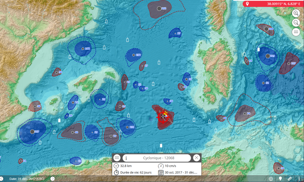
Eddies detected in Delayed-Time (DT) for the entire period [1993 - present]. Variables provided include day-by-day, and for one rotation type (Cyclonic/Anticyclonic) : - Center position (Longitude and latitude of the center of the best fit circle with the contour of maximum circum-average geostrophic speed); - Amplitude (|SSH(local_extremum) – SSH(outermost_contour)|); - Speed radius (Radius of the best fit circle with the contour of maximum circum-average geostrophic speed); - Speed average (Average geostrophic speed of the contour defining the speed radius); - Speed profile (Profile speed average values from effective contour inwards to smallest inner contour); - Effective contour (Largest contour of the detected eddy); - Speed contour (Contour of maximum circum-average geostrophic speed for the detected eddy).
-
Multimission altimeter satellite gridded sea surface heights and derived variables computed with respect to a twenty-year mean. Previously distributed by Aviso+, no change in the scientific content. All the missions are homogenized with respect to a reference mission. The acquisition of various altimeter data is a few days at most. The sla is computed with a non-centered computation time window (6 weeks before the date).
-
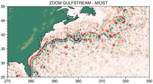
The MIOST (Multiscale Interpolation Ocean Science Topography) experimental altimeter product provides grids at delayed-time, at global scale, 1/10° spatial resolution, the sea surface height (MSLA and MADT) as well as the geostrophic currents, resulting from specific processing. Use for regional studies, ocean variability (mesoscale circulation,...).
-
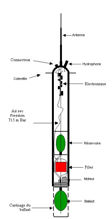
The RAFOS float technique (the reverse acronym of SOund Fixing And Ranging) is used to obtain sub-surface trajectories of floats by acoustic location. These floats are immersed at a constant depth and drift with the body of water in which they are immersed. The floats record the arrival time of the sound signals emitted by a network of fixed acoustic sources placed on moorings. They regularly come to the surface to transmit the data that they have recorded.
-
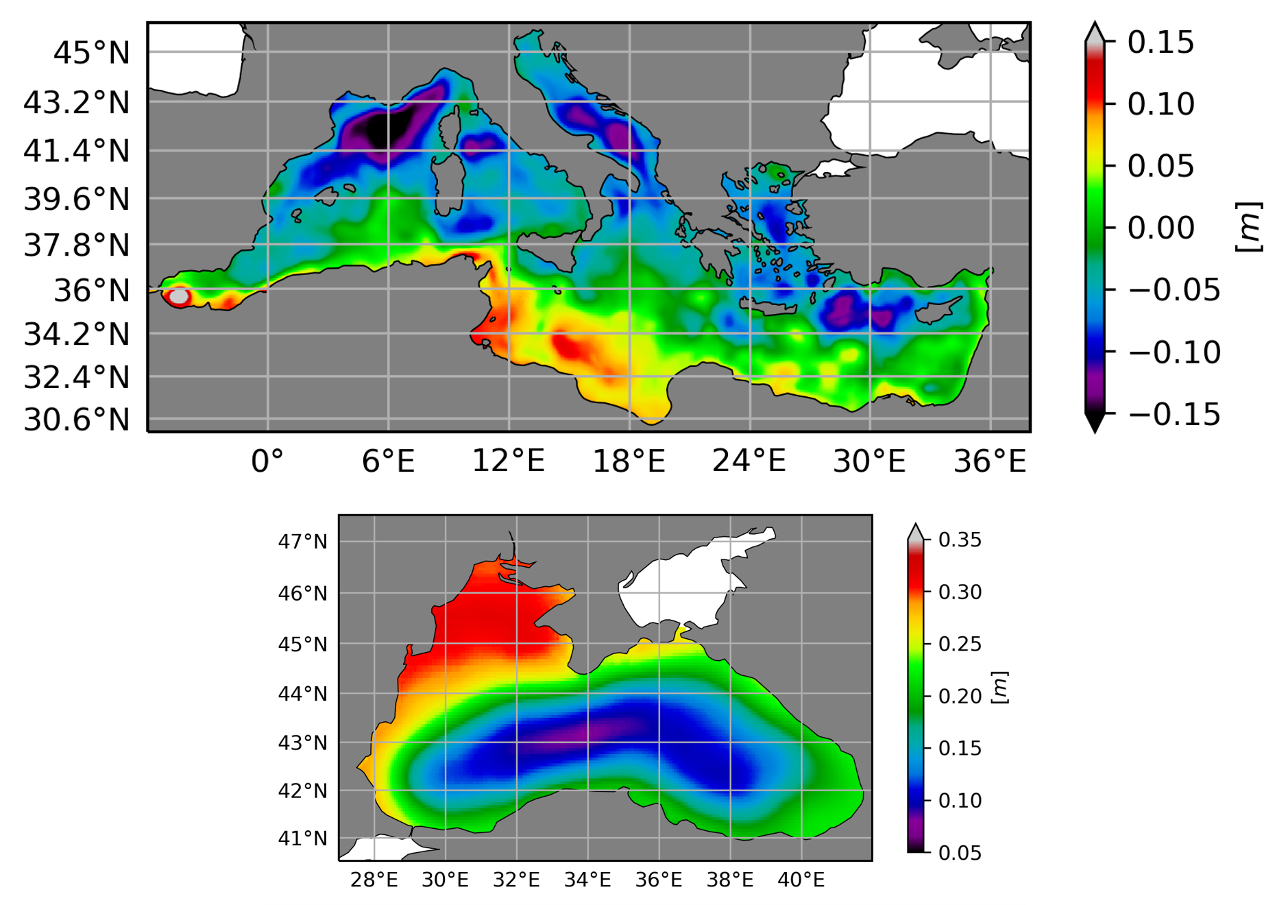
The Mean Dynamic Topography (MDT) is the temporal mean of the Sea Surface Height above the Geoid over a reference period (here 1993-2012). The Hybrid Mean Dynamic Topography contains the MDT-CNES-CLS18 for the global coverage and the MDT CMEMS 2020 for the Black Sea (MDT-CMEMS2020-BLK) and the Mediterranean Sea (MDT-CMEMS2020-MED).
-
This dataset provides detections of fronts derived from low resolution optimally interpolated remote sensing microwave SST L4 from REMSS over North Atlantic region. The data are available through HTTP and FTP; access to the data is free and open. In order to be informed about changes and to help us keep track of data usage, we encourage users to register at: https://forms.ifremer.fr/lops-siam/access-to-esa-world-ocean-circulation-project-data/ This dataset was generated by OceanDataLab and is distributed by Ifremer / CERSAT in the frame of the World Ocean Circulation (WOC) project funded by the European Space Agency (ESA).
-
This dataset provides surface Stokes drift as retrieved from the wave energy spectrum computed by the spectral wave model WAVEWATCH-III (r), under NOAA license, discretized in wave numbers and directions and the water depth at each location. It is estimated at the sea surface and expressed in m.s-1. WAVEWATCH-III (r) model solves the random phase spectral action density balance equation for wavenumber-direction spectra. Please refer to the WAVEWATCH-III User Manual for fully detailed description of the wave model equations and numerical approaches. The data are available through HTTP and FTP; access to the data is free and open. In order to be informed about changes and to help us keep track of data usage, we encourage users to register at: https://forms.ifremer.fr/lops-siam/access-to-esa-world-ocean-circulation-project-data/ This dataset was generated by Ifremer / LOPS and is distributed by Ifremer / CERSAT in the frame of the World Ocean Circulation (WOC) project funded by the European Space Agency (ESA).
-
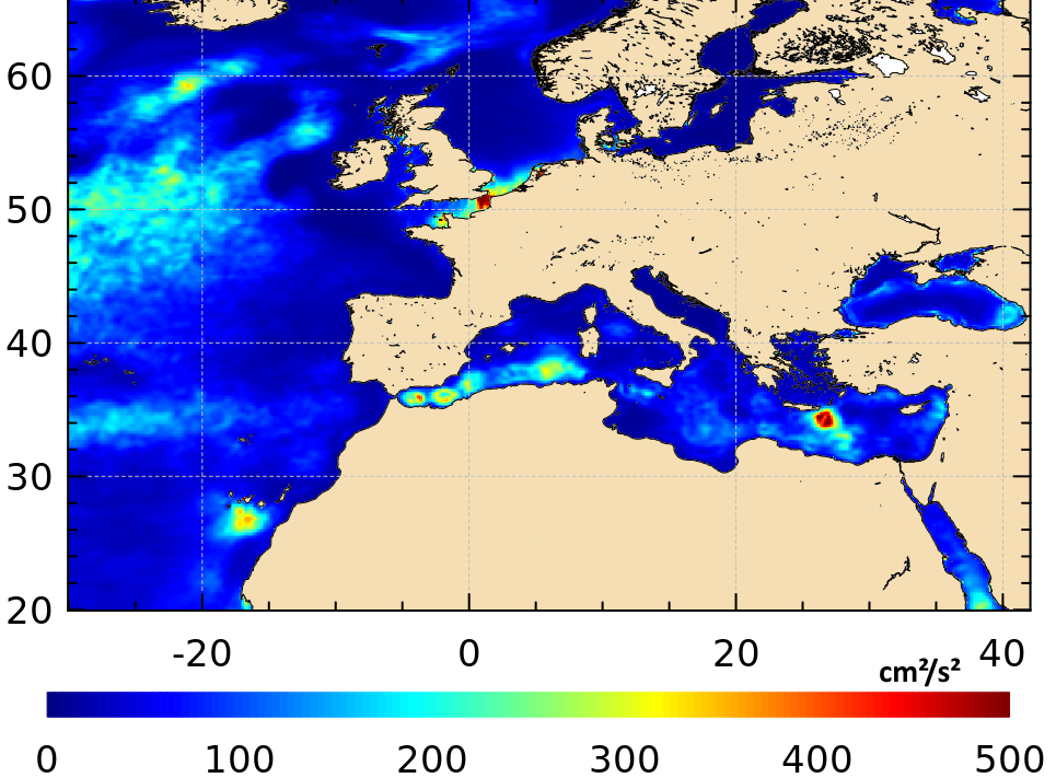
Multimission gridded Eddy Kinetic Energy (EKE) means derived from sea surface heights computed with respect to a twenty-year mean profile [1993-2012], and including the seasonal variability (NB. annual cycle is not removed) averaged, month by month from January 1993.